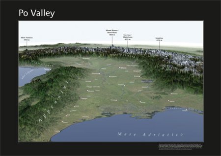
Po Valley panorama map
I often embark on side-projects to investigate new techniques, new software or just to try and expand my portfolio. However, the main problem I have with these side projects is trying to find the time to do them.

Po Valley postr
This is a perfect sample of such a project. A poster, intended to be printed at A2 size, of the Po Valley in Northern Italy. It’s been in production since the summer of 2008 and, in its current form, it’s been sitting on my harddisk since January. I finally decided to add it to my portfolio at freelancecartographer.com. I may still finish it and have it printed, but I have no idea when I get around to doing that.
For those of you interested in the production: I’ve combined SRTM (the post-processed version supplied by CGIAR) with Etopo1 elevation data using Global Mapper, then rendered the resulting terrain in Visual Nature Studio, using the free 250 m resolution True Marble imagery as overlay. The rendering had to be done in segments due to memory constraints (high resolution and the atmospheric effects being used , these segments were combined in Photoshop, where I also tweaked the contrast of the image a bit and highlighted the major rivers. Then the labels were added in Illustrator, using a 2nd, low-res reference render from Visual Nature Studio, which featured labels placed on the major cities and mountain peaks. Additional cities were added by triangulating their positions.
April 24, 2009 at 14:32
[…] Hans van der Maarel on GIS and mapping put an intriguing blog post on Po Valley panorama mapHere’s a quick excerptI often embark on side-projects to investigate new techniques, new software or just to try and expand my portfolio. However, the main problem I have with these side projects is trying to find the time to do them. Po Valley postr This is a perfect sample of such a project. A poster, intended to be printed at A2 size, of the Po Valley in Northern Italy. It’s been in production since the summer of 2008 and, in its current form, it’s been sitting on my harddisk since January. I finally decide […]
April 24, 2009 at 22:57
[…] hansvandermaarel placed an observative post today on Po Valley panorama map « Hans van der Maarel on GIS and mappingHere’s a quick excerptA poster, intended to be printed at A2 size, of the Po Valley in Northern Italy. It’s been in production since the summer of 2008 and, in its current form, it’s been sitting on my harddisk since January. I finally decided to add it to … […]